Hanes Valley – Lynn Headwaters to Grouse Mountain
Stretching
from Lynn Creek crossing in Lynn Headwaters Regional Park to the top of Grouse
Mountain, this backcountry hiking trail offers spectacular views, aside from
that of Hanes Valley, of Crown Mountain, ‘the Camel’ and offers a quick detour
to Norvan Falls. Hiking the trail involves creek crossings (log balancing
acts), mud puddle dodging, about 1.5kms of scrambling over scree fields, chain
pulling and a gondola ride down Grouse Mountain.

§ Prep Time: 10mins
§ Travel Time: 45-90mins.
§ Hiking Time: 5hrs (rated: 7-9)
Ingredients
Makes for a one-way
day hiking trip from Lynn Headwaters Regional Park to Grouse Mountain Super
SkyRide.
G1. One guy
G2. One backpack
G3. 3 litres of water
G4. TransLink Skytrain 996, SeaBus, Buses 228
and 236
T1. Distance - 16km
T2. Elevation Gain - 1320m
Review
A
member of the extensive North Shore circuit of hiking trails, the Hanes Valley
Trail proved to not only offer-up extraordinary views and an escape from the
masses that traverse many North Shore hiking trails but additionally proved
strenuous enough to satisfy those seeking more of a ‘workout-based’ hike. It
was a Sunday morning in late July when I decided, more or less on a whim, to
hike from Lynn Headwaters to Grouse Mountain.
The
Decision
It
was forecasted to be a scorcher, at least by Vancouver standards, the day I
woke up with not a plan, thought, or notion of hiking the Hanes Valley Trail.
Saturday, merely a day before, a few friends and I had ventured to
Whistler-Blackcomb to try mountain biking for the first time; read mountain biking. Needless to say the
adventure was amazing but it left my legs feeling a bit weak. Regardless, when
I rolled out of bed that Sunday morning it seemed as if nothing would stop be
from venturing into the backcountry.
I
left the house at 10:45am equipped with my day pack and three liters of water
(mostly ice cubes) in my hydration pack. I was off to the north shore, where I
was still unsure. Normally I would drive myself over to North Vancouver in my
truck but in an uncharacteristic change of events I had purchased a bus pass
earlier in the month and through, heck, why don’t I see if I have use public
transit to get to and from my hike. By the time I hit the Skytrain I quickly
realized that no matter where I wanted to hike public transit could get me
close.
Public
Transit – Trail
Following
a quick stopover at the Waterfront Skytrain Station in Vancouver where I picked
up a foot long (individually wrapped) Subway sandwich I was on the SeaBus
Heading to North Vancouver with the intention of hiking the Hanes Valley Trail.
About three weeks prior I had hiked from Lynn Headwaters to Lynn Lake when I
saw the turnoff for Hanes Valley. At the time I promised myself I would attempt
that hike before the snow hit. Now was my chance.
When
the Seabus (aka walk-on passenger ferry) docked in North Vancouver I headed for
bus 229; turns out the directions provided on the Lynn Headwaters Regional Park
website are incorrect as it is in fact bus 228 that drops you off at the
entrance of the park. Lynn Headwaters Regional Park is quite simply beautiful.
The
Hike
I
arrived at the entrance to Lynn Headwaters slightly before 12noon. From the
entrance of the park I hiked 1.5km along Valley Trail (easy) skirting and
eventually crossing Lynn Creek. As I crossed the bridge over Lynn Creek and
dodged countless tourists and day hikers I admired the remnants of an old hydro
dam across Lynn Creek; resultant pooled water providing refreshing dipping
holes for dogs and people alike. Satisfied I down Lynn Loop Trail (easy);
Valley Trail seamlessly becomes Lynn Loop Trail at the on the eastern side of
Lynn Cree. I continued down Lynn Loop Trail for 1.8 kilometers quickly meeting
the intersection of Lynn Loop Trial, Cedars Mill Trail (easy) and Headwaters
Trail (intermediate). Having already taken the path most taken, that of Cedars
Mill Trail, on an early hike I decided to branch east and followed Lynn Loop
Trail for another 0.3 km eventually tying into Headwaters Trail. I followed
Headwaters Trail for 2.0 kilometers to the northern junction of Cedars Mill
Trail and Headwaters Trail, an area known as Third Debris Chute, the first
North Shore Rescue cache location. The decision to divert onto Headwaters Trail
resulted in significantly more elevation gain than I had expected but served
the purpose of diverting me away from the heavily travelled leash optional
Cedar Mills Trail.
The
Headwaters trail continues for another 3.0 kilometers to the junction of the Hanes
Valley Route. From Third Debris Chute to Hanes Valley Junction, Headwaters
Trail takes hikers through a forested stand of cedars just out of view of Lynn
Creek. This section of trail is heavily used by day hikers, the majority of who
hike to either Norvan Falls or the mental suspension bridge that spans Norvan
Creek. The junction to Coliseum Mountain via Coliseum Route is also located
along the Headwaters Trail, approximately 2km north of Third Debris Chute. At
the suspension bridge it is typical to see people picnicking and young children
and dogs splashing in shallow pools along Norvan Creek. Normally I would stop,
take in the sights and have a quick lunch (I love lunching at creek crossings);
however, as it was now pushing 1:30 pm I thought it best to continue for another
kilometers to Hanes Valley Junction before stopping. With that I crossed the
suspension bridge and continued down the trail.
When
I arrived Hanes Valley Junction I looked north up the trail to the continuing
section, that of Lynn Lake Route that brings hikers along, in and across Lynn
Creek to Lynn Lake. Having hiked to Lynn Lake only three weeks ago I was
surprised by the nostalgic feeling that hit me upon seeing the sign “Warning,
you are entering the backcountry”. I continued left down a steep hill to Lynn
Creek along the Hanes Valley Route (challenging) where I stopped and lunched.
It was now 2:00pm.

Following
lunch I crossed Lynn Creek by balancing on a series of large logs that created
a strainer all the while thinking back to my swift water rescue training, my
instructors words still resonating in my head ‘avoid strainers at all costs’,
‘strainers will kill you’, you’re better to go over a waterfall than into a
strainer, just joking, but truly’. On the other side I continued up Hanes
Valley Route, a continual 2.5 kilometer uphill slog from Lynn Creek through
damp, often very muddy forest to the North Shore Rescue helipad in Hanes
Valley.
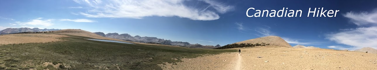
Making
up for the dark-wet slog up from Lynn Creek, hikers are welcomed by a sudden
departure from the forest to open meadows in Hanes Valley. The trail quickly
spits hikers out into the middle of Hanes valley where spectacular views of
surrounding mountains (Goat and Crown to the north, west and south; Mount
Burwell, Coliseum and the Needles to the east) and the eventual grueling
scramble up scree fields to Crown Pass (very challenging) can be seen. Arriving
in Hanes Valley I joined two other hikers (one male and one female) who were
sitting on the North Shore Rescue helipad taking in the scenery and some much
needed water and calories. By this time it was 3pm and the departure from the
forest to exposed valley proved hotter than one might expect at about 26
degrees Celsius with no shade. Following a quick chat I pushed up the trail.
Hanes Valley Route had now accurately become Steep Rock Slope (very challenging);
what lay ahead was supposedly the hardest part of the hike.
Having
thoroughly read trail reviews and the brochure I picked up from the information
kiosk at Lynn Headwaters I thought I knew what lay ahead; trails designated as
very challenging routes due to the need to scramble over poorly marked steep scree
fields. As it turns out, much to my surprise, this classification was fairly
accurate.

During
my adventure up Steep Rock Slope I passed three men on their way down the scree
field to presumably Hanes Valley, two women tucked under a tree taking a
well-deserved break from the direct sunlight and their boyfriends, whom when I
passed insisted on having a ‘I’m manlier than you competition’ whereby they
continually affirmed that the scramble ‘was not that strenuous’ and the
temperature, at best was ‘only a little hot’; pfff. I’ve hiked through the
Mohave Desert; scrambling over those granite rocks sure seemed hot to me.
At
the top of Crown Pass, the end of Steep Rock Slope the climb is not over.
Hikers are welcomed with a continuation of forest hiking, today – thankfully in
the shadows of tall trees for 1 kilometer up from Crown Pass to Little Goat
Mountain (you do not summit). This hike is a gradual climb up to the junction
of the Alpine Trail (intermediate); this section involves some high-stepping and
some chain pulling.
Once
at the junction of the Alpine Trail hikers continue south toward Dam Mountain
and Grouse Mountain via the Ridge Trail (intermediate) or Alpine Trail to the
Grouse Mountain Alpine Chalet and the Grouse Mountain Super SkyRide gondola
(approximately 1.7 kilometers). $10 gets you a one-way trip down the mountain to
the parking lot at the Base of Grouse Mountain. By the time I hit the Grouse
Mountain Alpine Chalet on top of Grouse Mountain it was 5pm. I purchased a beer
and enjoyed the other half of my Subway sandwich.
Public
Transit – Home
Following the gondola trip to the bottom of
Grouse Mountain I hopped on bus 236 to Lonsdaly Quay where I caught the SeaBus
from North Vancouver to the Waterfront Station in Vancouver. I boarded the
SkyTrain and walked the few block back to my house arriving at 6:45pm.
- Steve
- Steve